

Knocknagree [Cnoc na Groi]
Good walks are even better shared.
Overview
Knocknagree [Cnoc na Groi]
Knocknagree, standing at a commendable elevation of 648 meters, provides an enjoyable hike for both seasoned trekkers and those just getting their walking boots muddy. Located in the picturesque Cork and Kerry region of Ireland, this Marilyn isn’t just a bump on the map; it’s a top that rewards climbers with spectacular views and an invigorating day out.
Geology
The mountain's striking formation comprises sandstone and shale that adds both texture and character. As you journey through its varied landscape, geology enthusiasts will thrive on spotting the different rock types and formations. And if you start thinking about questioning your own existence amidst the great outdoors, fear not; it’s all part of the journey!
Routes
Knocknagree Loop
A circular trek that kicks off from Knocknagree village, this path spans approximately 8 km and can be tackled comfortably in about 3 hours. The moderate difficulty makes it accessible to many outdoor enthusiasts keen to experience the mountain’s allure.
Summit Features
Reaching the summit, you’ll be greeted by a substantial cairn, a nod to previous hikers who wanted to ensure no one got lost. From up here, it’s easy to feel on top of the world — which is essentially true!
Terrain
Expect a blend of grassy areas, rocky stretches, and some boggy spots that may catch you off guard if you're not careful. So, lace up your best boots or risk losing a shoe in the marshy bits!
Views
The panoramic vistas offered at the summit are breathtaking, revealing sights stretching towards the MacGillycuddy's Reeks and the lush valleys below. The best time to soak in the scenery is during spring and autumn when the countryside is awash in vibrant colours.
Hazards
Although the trail is relatively tame, sudden weather shifts can throw a spanner in the works. Watch your footing and be prepared for possible slippery rocks post-rain. Safety first, laughter second!
Access
Knocknagree is easily reachable, with parking in the village just a stone's throw from the trailhead. If you prefer public transport, local buses connect through to Killarney and nearby villages, with Millstreet being the closest larger town, merely 10 km away.
Facilities
For basic needs, Knocknagree boasts a friendly local shop. However, for a more substantial café experience or toilets, hop on over to Millstreet.
History
The name ‘Cnoc na Groi’ could weave tales as rich as the Irish landscape itself. Although the meaning suggests 'Hill of the Grief,' it remains a gentle mystery. Perhaps it’s the sigh one makes upon finally reaching the top! Historically, the hill has served as a social gathering point, adding layers of cultural significance to any trek here.
In summary, a jaunt up Knocknagree is well worth the effort, blending stunning views and fascinating geology into one accessible package. Grab your gear, lace your boots, and prepared to tackle a trail that embodies the spirit of the great outdoors!
Explore routes near Knocknagree [Cnoc na Groi]
Public walks starting within 80 km of this hill. Nearby does not mean a route reaches the summit; check its map and access before setting out.
No public routes are currently listed within 80 km of Knocknagree [Cnoc na Groi] on Walkmates. This does not mean there are no paths here. Explore the map and check local access information before planning a walk.
Route planning notes
These notes describe possible approaches, not verified navigable routes or permission to cross land. Check current paths, local access rules and conditions before setting out.
Knocknagree Loop
A circular route starting from the village leading around the mountain, providing scenic views and a moderate workout.
Make a day of it, together
Find someone to share the walk with, or organise a day out along a route you like.
Photo Gallery
View all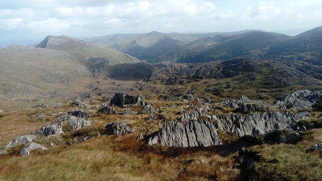 Photo could not load
V7250 : Glen Mor
Ernest Riordan
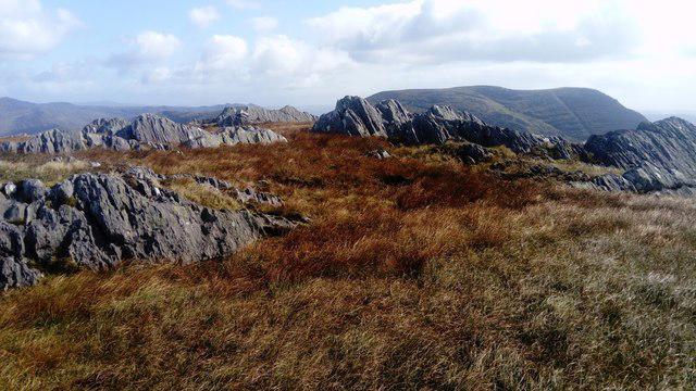 Photo could not load
V7250 : Knocknagree Summit
Ernest Riordan
Hill facts and local notes
Classifications
Elevation
586m
1,923 ft
Prominence
132m
Coordinates
51.6937, -9.8421
V726505
OS Map
84
At the Summit
The summit features a large cairn, a remnant of previous climbers' efforts to mark the highest point. The views from here will make you feel like the king or queen of the hill.
Terrain & Geology
The mountain is primarily composed of sandstone and shale, giving it a rugged yet beautiful terrain, perfect for both geology buffs and hikers alike. This mix contributes to the striking views and diverse flora along the routes.
Views & Scenery
On a clear day, you can see the distant peaks of the MacGillycuddy's Reeks, along with the lush valleys that adorn the landscape beneath you.
History & Heritage
Name Origin
Cnoc na Groi translates to 'Hill of the Grief' in Irish, although there's little concrete history of what the 'grief' refers to — perhaps it's just the hike back down after all the climbing!
Historical Significance
The mountain has been a site of cultural significance for local communities, often featuring in gatherings and celebrations, making it not just a hike but a link to local heritage.
Getting There & Facilities
Check current local access restrictions, parking rules and transport timetables before travelling. These notes do not confirm public access to the summit.
Parking
Parking is available in the village of Knocknagree, just a short walk from the trailhead.
Public Transport
The nearest bus service is available from Killarney, which provides access to local villages, including Knocknagree.
Nearby Facilities
Knocknagree offers a quaint local shop, but for more facilities, head to Millstreet or nearby towns where you can find cafes and toilets.
Safety Information
Known Hazards
- Beware of sudden weather changes typical in the Irish countryside. Also, remain cautious of uneven terrain and avoid slippery rocks after rains.
General Safety Tips
- Check weather conditions before setting out
- Carry appropriate clothing and equipment
- Let someone know your planned route
- Take a map, compass, and GPS device
- Carry emergency supplies: food, water, first aid kit, torch
Hills
Some common questions about the hills answered
Are there group walks up Knocknagree [Cnoc na Groi]?
Many walkers use Walkmates to join or organise walks with others. You can check for group walks around Knocknagree [Cnoc na Groi] through the maps
Are there other walkers around Knocknagree [Cnoc na Groi]?
Activity varies by location and time, but Walkmates lets you see whether others have shared walks or shown interest in this area. Find other people through the walking friends search walking friends for Knocknagree [Cnoc na Groi] search or of course create your own walk for Knocknagree [Cnoc na Groi]
Can I organise a walk to Knocknagree [Cnoc na Groi]?
Yes. If there aren’t any walks listed already, you can create a walk and make it available for others to join.
If you're signed up to Walkmates, you can create a walk to Knocknagree [Cnoc na Groi].
How do I find a walk up this hill?
There are often multiple ways to walk this hill, depending on experience and route preference. Walkmates helps you explore walks and routes that others have shared.
Can I suggest a new route up Knocknagree [Cnoc na Groi]?
Yes. You can suggest or create routes to share with others. Walkmates focuses on the social side of walking, so routes are used to help people organise walks and explore areas together, rather than as detailed navigation tools or route libraries.
Other uses really appreciate knowledgeable walkers sharing their routes. Share your favourite route to Knocknagree [Cnoc na Groi] here
The is an error or something incorrect about this hill. How do I let you know?
We always strive to keep the information on Walkmates as accurate as possible. If you find an error, please let us know through the contact form and we'll aim to correct it as quickly as possible
Community Discussion
Comments
Location
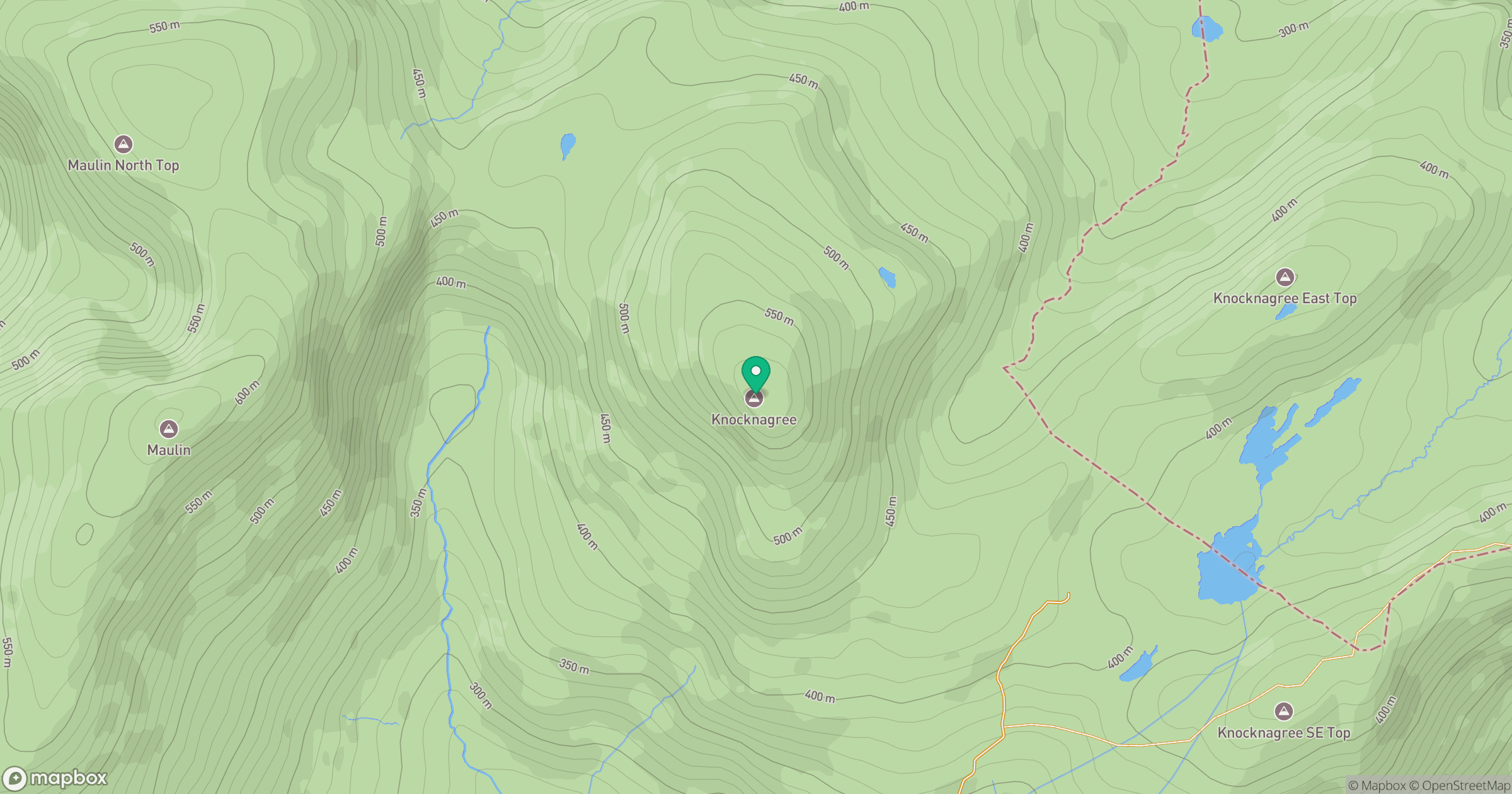
Grid reference: V726505
View on OpenStreetMapOpens a map in a new tab, centred on the hill.
Hills within 30 km
Straight-line distance, not a walking route or confirmation of access.
Maulin [Malainn]
621m
Eskatarriff [Eisc an Tairbh]
600m
Coomacloghane [Com an Chlochain]
599m
Lackabane [Leaca Bhan]
603m
Hungry Hill [Cnoc Daod]
685m
No comments yet. Be the first.